Mayapán Ancient city in Mexico
Introducing Mayapán
The Mayapán Archaeological Zone is located south of the city of Mérida in the Yucatan Peninsula of Mexico. The site is not widely visited, but is open to the public for a small fee. It is historically important because it was the last big Mayan civilization thriving before the arrival of the Spanish. It was founded about 1000 AD and was part of an alliance with Chichen Itza and Uxmal before Mayapán overcame its allies and emerged as the sole ruler of the region. It was the cultural and political capital of the Yucatan during this time period, the end of the Post-Classical period, but was ultimately overthrown itself. A revolt was organized about 1440, and the ruling family was killed, and Mayapán was sacked, burned, and abandoned.
The four square kilometer city itself had an estimated 12,000 – 17,000 inhabitants, and was unique in that it was surrounded by walls. It is compared to Chichen Itza, but on a less grand scale. This plus the existence of the wall indicates a greater interest in warfare among Mayapán’s rulers.
The Park
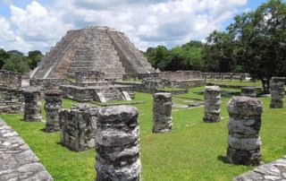
The Mayapán Archeological Zone is a four square kilometer area enclosed within a massive wall and the surrounding area as well. There are 4000 structures within the wall, but it is centered on a central plaza on which some of the buildings have been reconstructed, including a large pyramid and an observatory. It is an active archeological site, and scientists are at work excavating and rebuilding the city.
The smallish, well-maintained park is open 8 a.m. to 5 p.m. daily and a small entrance fee is charged. Parking is provided as well as restrooms, but not food. It is not a busy park. There are few tourists because it is not served by the numerous tour buses seen at the larger sites such as Uxmal and Chichen Itza. Allow 1 – 2 hours.
Major Attractions
Some believe that the limestone used in Mayapán’s construction was inferior to that used in other sites, and the workmanship as well. For this reason, and because of possible political reasons, the buildings at Mayapán are not equal in size or quality to those at Chichen Itza, for example. Some of the buildings seem to be patterned after those of Chichen Itza, especially the large pyramid “El Castillo,”and the round building “El Caracol.”
The ceremonial center is a group of temples, colonnaded halls, shrines, altars and platforms. This main square was bordered by government, administrative and religious buildings, as well as the homes of the rulers. The grounds contain scattered statues and numerous decaying stepped pyramids, and also colorful painted murals and stucco reliefs.
The site is surrounded by a nine kilometer stone wall with twelve gates including some with vaulted entrances. Mayapán has no ballcourts.
The large residential areas of the site are made up of dwellings and associated domestic structures. The houses are often arranged in small patio groups surrounding small courtyards. There are many cenotes (limestone sinkholes filled with water) in the residential areas of the site.
How to Get There
First of all don’t confuse the Mayapán Archeological Zone with the town of Mayapán. They are two different locations. The Mayapán ruins are located a few miles south of the town of Telchaquillo, about 25 miles south of Mérida and about 60 miles west of Chichen Itza.
Tours do not go to Mayapán, so you will have to get there yourself. Rent a car or take a taxi. Telchaquillo is located on the two-lane highway 18, and the ruins site is well marked a short distance south of Telchaquillo.
Round-trip second-class bus service is available from the Noreste station in Mérida. Again, be sure you get on a bus to the ruins, not the town. They are far apart.
Bring water and snacks, and protection from the sun. It will be hot year round.
Uxmal Mayan Ruins Mexico
Uxmal Mayan Ruins In Mexico
Uxmal (pronounced “oosh-MAHL”) is a World Heritage site, one of the most visited, and said by some to be the most attractive of the archaeological sites. It is located about halfway between Campeche and Merida in the Yucatan Peninsula of Mexico, and is visited by thousands annually. It is one of the best-restored and maintained archaeological parks and is home to magnificent examples of puuc architecture and construction.
The main ruins of Uxmal cover about 150 acres, with residential districts spreading further beyond that. Uxmal occupies a grassy savannah surrounded by forest and its buildings were adapted to the varied elevations of the hilly landscape.
Allow at least half a day for a first visit.
History
It is believed that Uxmal was the capital of a regional state that developed between 850 to 950 AD, although its inhabitants are thought to have lived in the area as far back as 800 BC. At its peak it had an estimated population of about 25,000 and was one of the largest cities in the Yucatan Peninsula. But after about 1000 AD all major construction ceased at Uxmal, and the site was abandoned around the time the Spanish arrived. No Spanish town was built here and Uxmal was soon after largely abandoned.
Puuc Region
The word “puuc” is derived from the Maya term for “hilly country” hence, the terms Puuc region or Puuc hills in the area around Uxmal. The term Puuc is also used to designate the architectural style of ancient Maya sites located within the Puuc hills. It is a mature style reaching its zenith during the Terminal Classic period.
In the Puuc architecture buildings were decorated with carefully cut veneer stones set into a concrete core. This is an improvement over the previous method of using stones piled on top of eachother and held together with plaster for the core. This advanced construction method allowed for slightly larger and more stable interior rooms and may account for the excellent condition of many of the thousand-year-old buildings at Uxmal. Puuc architecture has several predominant features, most notably constructions with a plain lower section and a richly decorated upper section. Carvings most commonly found include serpents, lattice work and masks of the god Chac.
Within a 10 mile radius of Uxmal are the four smaller ancient towns of Kabah, Sayil, Xlapak, and Labna. Together with Uxmal, these places make up the Puuc Route. A large raised stone sacbe (roadway) links Uxmal with the site of Kabah, about 10 miles to the south.
The Park
Uxmal archeological park is open 365 days a year from 8 a.m. to 5 p.m. with a sound and light show in the evening. There is an entrance fee of about $10 and an additional fee for the light show. Facilities include cafeterias, souvenir shops and toilet facilities. There are also local vendors, a small museum and auditorium. There are at least three hotels within walking distance of the park.
Major Attractions
The Governor’s Palace is a long low building atop a huge platform. Built in the 9th and 10th centuries, its 320 foot long mosaic facade is one of the longest in pre-Columbian Mesoamerica and features 103 stone masks of the rain god Chac. There is an open plaza in front of the Palace containing the Jaguar Throne, carved like a two-headed jaguar. The Governor’s Palace may have had astrological significance as well. It is slightly turned from the other buildings around it, so that its central doorway is in alignment with Venus.
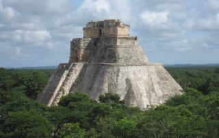
The Pyramid of the Magician is the tallest building at Uxmal with a height of 115 feet and unusual round corners. It is so named because of a Mayan legend about a Magician or Dwarf who build this pyramid in one night. Actually, it was begun in the 6th century AD and regularly expanded through the 10th century. The pyramid is unique among Mayan structures because of its rounded sides, height, and steepness. There are actually five pyramids there, each larger and built over the one beneath as was customary among such Mayan pyramids.
The Nunnery Quadrangle was so named by the Spanish, but was actually a 74-room governmental palace. It is the finest of Uxmal’s quadrangles of long buildings with elaborately carved facades on both the inside and outside faces.
A large ballcourt for playing the MesoAmerican ballgame is inscribed with hieroglyphics informing us that it was dedicated in the year 901.
Several other temple-pyramids, quadrangles, and monuments, some of significant size, and in varying states of preservation, are also at Uxmal. The majority of hieroglyphics are on collections of stone Stella depicting the ancient rulers grouped together on single platforms.
How to Get There
The closest airport is in Merida, about an hour and a half away by car. The easiest way to see the ruins is to book a tour at Merida. They are available for Uxmal itself or as part of tours of the entire Puuc Route which include Uxmal and four other smaller sites.
Public transportation is not as readily available in this area, although there are buses from Merida to Uxmal, but the schedule does not permit one to see the light show in the evening. Some may wish to rent a car and drive the 70 miles from Merida to Uxmal following route 261 towards Campeche. The entrance is well marked.
Protect yourself from the elements by bringing a hat, sunscreen and water.
Mexico’s Yaxchilan Ruin
Yaxchilan Ruins, Ancient Mayan Site in Mexico
Yaxchilan is an ancient Maya city located on the banks of the Usumacinta River in the southern state of Chiapas, Mexico, near the border with Guatemala. Yaxchilan was a large center, important throughout the Classic era, and the dominant power of the Usumacinta River area. It dominated such smaller sites as Bonampak, and had a long rivalry with Piedras Negras to the north, and it was even a rival of Palenque, with which Yaxchilan warred in 654.
The site is particularly known for its well-preserved sculptured stone lintels set above the doorways of the main structures. These lintels, together with the stelae (stone tablets) erected before the major buildings, contain hieroglyphic texts describing the dynastic history of the city.
Yaxchilan is within a comfortable driving distance from other popular archeological sites in Chiapas such as Bonampak archeological site (13 miles southeast); Palenque (about 120 miles north); and Piedras Negras (25 mi north across the river in Guatemala). Yaxchilan is a mini-adventure because it is not accessible by roads. You have to fly in or better yet take a boat from Frontera Corozal. (See How to Get There, below)
History
Yaxchilan has its origins in the Preclassic Period, but reached its peak during the Late Classical period of 800 to 1000 AD. The known history of Yaxchilan starts with the enthronement of Yopaat B’alam I, on 23 July, 359, and over the centuries Yaxchilan developed into a very powerful and influential urban and trade center on the banks of the Usumacinta River. Much of what is known of the history of the city comes from the hieroglyphic texts in the ruins.
As with most Mayan cities, it was abandoned and later was covered in jungle vegetation before the arrival of the Spanish in the 1500′s.
The site was briefly mentioned in 1833 in a published article by the Royal Geographic Society, and gradually came to the attention of the Europeans and North Americans over the following century, who explored and mapped the site. The Mexican Instituto Nacionale de Antropologia y Historia (INHA) preserved the central portion of the site. Yaxchilan has been a remote location, accessible only by small plane or long boat rides on the Usumacinta River, since there were no roads within 100 miles. However, the federal government constructed a highway, The Carretera Fronteriza also known as Highway 307, into the area in the 1990′s opening it to tourism.
The Park
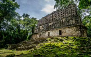
The Yaxchilan Archaeological Park is open seven days a week from 8 to 5, and the usual small entry fee of less than US$10 is charged. It is best known for its detailed facades and large ornamented roof combs and its lintels. Over 120 structures made up this city, grouped into 3 main areas: the Great Plaza, the Grand Acropolis and the Small Acropolis.
When you get off your boat at the small pier, you will walk up a ramp that leads to the entrance where you will find the ticket booth, rest rooms, drink stand and local guides who will take you through for a fee. You go through a dark tunnel under a building and then into the north west corner of the Grand Plaza—an open space overlooking an ancient plaza, surrounded by structures in varying conditions.
The site contains impressive ruins, with palaces and temples around a large plaza. The architectural remains extend across the higher terraces and the hills to the south of the river, overlooking both the river itself and the land beyond. Yaxchilan is famous for the large quantity of sculpture, such as the monolithic carved stelae and the reliefs carved on stone lintels spanning the temple doorways. In fact, more than 120 inscriptions have been identified on the various monuments. The major groups are the Central Acropolis, the West Acropolis and the South Acropolis.
Major Structures
The archeological items of most interest at Yaxchilan are the numerous carvings on lintels (stone blocks above doorways), steles (stone blocks or tablets) and carved hieroglyphic stairways depicting events and people of the classical era. Several were removed from the site in the 1900′s and are now in museums in London and Mexico City. All the lintels, steles and carvings are numbered as are all the buildings at the site.
One important carving is lintel 24, structure 23 which depicts a sacred blood-letting ritual which took place on October 26, 709. King Itzamnaaj B’alam II is shown holding a torch, while his wife draws a barbed rope through her tongue.
Other interesting or unusual buildings are building 17 (a sauna) and two ball courts.
Structure 19 in the Central Acropolis is also known as the Labyrinth. The structure is a temple with rooms spread over three levels, linked by interior stairways. Two sculptured altars are located in front of the structure, which still has the remains of a perforated roof comb.
The best preserved building is number 33, which you have to climb up to see properly.
How to Get There
By Air: The closest airport to Yaxchilan is Villahermosa and Tuxtla Gutierrez.
By Bus: Although there are some local buses traveling from Palenque to Frontera Corozal (the small town where the boats embark), these are not recommended.
By Car: You need to travel to Frontera Corozal on Highway 198 and park your car in town. Driving in Chiapas requires special caution to avoid serious problems. Do not drive after dark. You will be driving in a remote area with no gasoline stations or repair service. You will probably pass through at least one or more military checkpoint if you drive in Chiapas. Unless you are an experienced driver in Mexico, it is best to take a tour instead of driving yourself or taking the bus.
Boat Ride: To reach Yaxchilan, you must take a boat ride from Frontera Corozal, a small town that also has a good restaurant and a hostel. If you are part of a tour then all the arrangements will be made for you. Otherwise you will need to hire a boat yourself speaking Spanish. The boat trip is pleasant and takes an hour to get to the ruins, and an hour and a half to get back. You may see wildlife including toucans, howler monkeys and crocodiles. Yaxchilan has a small pier where you get off the boat and get back on again for the return trip. Your boat driver will tell you to return in 90 minutes, but will wait longer if you can make this clear and leave a little extra tip.
Tours: Tours are available from Palenque that visit Yaxchilan and nearby Bonampak. It is best to take a tour due to the remote location of these parks. The tour buses travel in convoys with police escort departing Palenque about 6:30 am. and returning about 12 hours later. It is a scenic drive on Highway 307. Don’t drive after dark, and exercise caution on this road. In fact, why not join the bus convoy if you really need to drive yourself.
Protect Yourself – This is jungle climate, hot and humid. Wear loose fitting comfortable clothes of cotton, no denim. Sturdy shoes are needed. Protect yourself with sun screen, bug spray, a hat, sun glasses and water. Drink water before you get thirsty.
Oxkintok: The Mayan City of Tzat Tun Tzat
Oxkintok: The Mayan City of Tzat Tun Tzat
Introducing Oxkintok
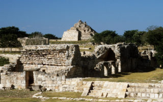
Oxkintok is an archaeological site on the Yucatán Peninsula, located at the northern tip of the Puuc hills, a short distance east of Maxcanú and about 40 miles from Mérida. It is not far from Uxmal and the Ruta Puuc. The site is big, about three square miles, and contains pyramids, plazas, and palaces scattered amid high grass and trees. It is well-maintained but sparsely visited, and you may be the only visitor on the site.
Oxkintok is one of the oldest cities in the Yucatan with hieroglyphic inscriptions showing some of the earliest dates known in the Yucatán. It was settled as early as 350 BC, reached its peak in the Early Classic Period, and was continuously inhabited as late as 1000 AD. It was once an important ceremonial center in the Puuc region, and its architecture is representative of that style.
The Park
The site of Oxkintok Archeological Zone is open to visitors with a small admission fee from 8 to 5 daily. The only facility at the site is a free parking lot and a small palapa which serves as a ticket booth, but no rest rooms, refreshments or museum. The artifacts have been removed to the Museum of Anthropology in Mérida. Guides are available, and a nearby attraction is the Calcehtok caves.
Major Attractions
The most popular structure at the site is the the labyrinth named “tzat tun tzat,” also known as Satunsat. This is a relatively small structure with a maze of vaulted tunnels connected by small gates and narrow stairs. It is easy to get lost inside, so bring a flashlight.
The central nucleus of Oxkintok is made up of a large plaza around which are three groups:
The Ah Canul group is an arrangement of several classes of buildings such as temples, pyramids, palaces, altars, stairs, squares and sacbeob. Notable among these are the The Chi’Ich palace, which belongs to the Puuc period with its characteristic dome and ornamentation of mosaic stone. Anthropomorphic stone columns, the men of stone, are located on the eastern side of the Canul group. These figures are fat beings dressed in decorated garments with intertwined robes, mesh vests and chest armor.
The May group is the best restored group of structures in the site. The pyramid is another labyrinth with painted and decorated walls.
The Dzib Group is the least known and least restored of the three groups. Six structures can be visited including the ball court, the temazcal and The Chaac Palace. During the restoration of the ball court, a circular hole was unearthed, and it is believed to be an ancient steam bath used for the purification and cleansing of the ball game players and pregnant women.
How To Get There
Oxkintok is located outside of the town of Maxcanú which is roughly 30 miles southwest of Merida. Oxkintok is about 30 miles northwest of Uxmal and the Ruta Puuc, about halfway between Mérida and Campeche.
To drive from Mérida, take highway 180 to the site near the intersection of Highway 188 and 184. One day tours are available out of Mérida. One could also take the public bus to Maxcanú and take a cab to the ruins.
There are no rest rooms or refreshments available at the ruins, so visitors are advised to bring their own water and protection from the sun.
Tikal – Ancient Mayan City of Guatemala
Tikal – Ancient Mayan City of Guatemala
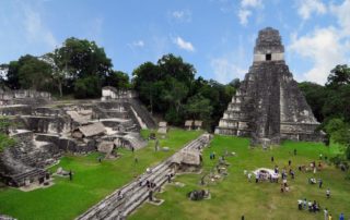
Tikal is a large archaeological site in Guatemala, the largest excavated site in the Americas. It is Guatemala’s most famous cultural and natural preserve, and is located in the department (state) of El Petén. The ruins are part of Guatemala’s Tikal National Park and in 1979 it was declared a UNESCO World Heritage Site. Tikal was a Maya city of great power and size, the largest of Maya cities during the Classic Era over 1000 years ago; and the Mayans occupied this area from about 600BC to 900 AD. Today it is a fascinating and enjoyable site to visit, because of its remoteness and jungle setting. It is heavily visited, but not crowded because of its vast size. Many beautiful buildings have been uncovered and many more wait to be discovered and restored. It is possible to climb to the top of a few of the temples and get spectacular views from above the tree tops.
The closest large cities are Flores and Santa Elena, approximately 40 miles to the southwest; and Guatemala City, approximately 188 miles to the south.. Most tours to Tikal start from Flores or El Remate village which is located half way between Flores and Tikal ruins. There is no Tikal town and no stores for shopping to speak of.
History
Tikal was the capital of a state that became one of the most powerful kingdoms of the ancient Maya. Though monumental architecture at the site dates back as far as the 4th century BC, Tikal peaked during the Classic Period, about 200 to 900 AD. During this time, the city dominated much of the Maya region politically, economically, and militarily, while interacting with areas throughout Mesoamerica such as the great metropolis of Teotihuacan in the distant Valley of Mexico. It often clashed, conquered, traded with and engaged with other cities in the region, and was prosperous until the general decline of Mayan civilization about 900 AD, at which time it was abandoned. Tikal at its height, was a dominating and important economical and political power in MesoAmerica, but fell into ruins as did all the other such centers around 800 – 1000 AD. It was eventually consumed by the jungle.
The population of Tikal grew continuously starting in the Preclassic Period (approximately 2000 BC – AD 200), and peaked with the population of an estimated 120,000 by the year 830 AD. This was followed by a sharp decline in population in line with the general Mayan collapse.
The Mayans had a complex form of hieroglyphic writing that was found carved on the stele (stone tablets) and altars that dot most of the site. Pictures depicting events and the beliefs of the time, were carved in the lintels, stone steps,and various walls throughout the temples and tombs.
The lack of springs, rivers, and lakes in the vicinity of Tikal brings to light an amazing accomplishment: building a highly populous city with only supplies of stored seasonal rainfall. Tikal was able to prosper with intensive agricultural techniques which allowed the area to feed itself, but left it vulnerable to drought, which is thought by some to have played a role in the collapse of the Maya civilization. It is theorized that the most likely cause of collapse at Tikal is overpopulation and agrarian failure. The fall of Tikal was a blow to the heart of Classic Maya civilization, the city having been at the forefront for over a thousand years, with an ancient ruling dynasty. As Tikal and its hinterland reached peak population, the area suffered deforestation, erosion and nutrient loss followed by a rapid decline in population levels.
The ancient city became overgrown, and the hundreds of temples and other structures were lost to the jungle. The city lay hidden by the jungle for centuries. The local people, however, never forgot about Tikal and they guided Guatemalan expeditions to the ruins in the 1850s, and the site was visited by various explorers, archeologists and adventurers during the next 100 years, From 1956 through 1970, major archaeological excavations were carried out by the University of Pennsylvania which uncovered nearly 10 square miles of ruins. They mapped much of the site and excavated and restored many of the structures. This work has been continued by the Guatemalan government, and ongoing excavations are almost continuous.
The Park
The park’s main gate opens at 6 am and closes at 6 pm. Adult tickets are under US$20. Maps are available outside the Visitor’s Center, and walking trails wind through the temple complexes. The visitor’s center offers food and drink, but there is no ATM at the park or the adjacent hotels.
In the main area there is the parking lot, 3 hotels, a museum and visitors’ center, post office, campground, souvenir handicraft shops, and three local eating places. Also there is a guide service and information desk, and a restaurant overlooking the jungle. A smaller museum housing some of Tikal’s artifacts is located near the hotel area. No ATM. There is no Tikal village or town at the park other than the visitor center and gift shops. There is also lodging in Flores and El Remate.
Tikal National Park is made up of 222 square miles of jungle surrounding the ceremonial center. It is located within the 6,000 square mile Maya Biosphere in the northern part of Petén. The major architecture of the site is clustered upon areas of higher ground and linked by raised causeways spanning the swamps, and most of Tikal Park structures remain covered with jungle growth recognized only as large mounds of rocks over grown by trees. The partially restored area consists of nine groups of courts and plazas. There are 5 large temples. One of the most impressive and tallest structures is 230 feet high.
More than 285 species of exotic birds and animals live in the park. In addition, there are hundreds of orchid species and more than 30 hardwood species. Tikal is a bird watchers paradise, and is considered one of the best birding areas of Central America. Some of the wildlife species commonly seen in the park include: howler monkeys, spider monkeys, ocellated turkeys, coatimundi, crocodiles, and gray fox. Others not as common are jaguars, pumas and ocelots. Conspicuous trees at the Tikal park include gigantic kapok; tropical cedar, and Honduras Mahogany. The average annual rainfall is 76.6 inches.
Major Structures and Attractions
There are four architectural areas in the central cleared area: the Great Plaza, North Acropolis, Central Acropolis, and Mundo Perdido (Lost World Complex). The outstanding feature of these structures is their monumental size as high as 230 feet.
The architecture of the ancient city is built from limestone and includes the remains of temples that tower up to 230 feet high, large royal palaces, in addition to a number of smaller pyramids, palaces, residences, administrative buildings, platforms and inscribed stone monuments. There are also seven ball courts.
The limestone used for construction was local and quarried on-site. The holes left by the removal of stone were plastered to waterproof them and were used as reservoirs, together with some waterproofed natural depressions. The main plazas were surfaced with stucco and channeled rainfall into a system of canals that fed the reservoirs. The residential area of Tikal covers an estimated 23 square miles, much of which has not yet been cleared, mapped, or excavated. A huge set of earthworks has been discovered ringing Tikal with a 20 foot wide trench behind a rampart.
By the Late Classic, a network of sacbeob (causeways) linked various parts of the city, running for several miles. These linked the Great Plaza with Temple IV and the Temple of the Inscriptions. These causeways were built of packed and plastered limestone and helped the passage of everyday traffic during the rainy season and also served as dams.
The Great Plaza lies at the core of the site; it is flanked on the east and west sides by two great temple-pyramids. On the north side it is bordered by the North Acropolis and on the south by the Central Acropolis.
The North Acropolis, together with the Great Plaza immediately to the south, is one of the most studied architectural groups in the Maya area. After AD 400 a row of tall pyramids was added to the earlier Northern Platform, which measured 330 by 260 feet, gradually hiding it from view. Eight temple pyramids were built in the 6th century AD, each of them had an elaborate roof comb and a stairway flanked by masks of the gods. By the 9th century AD, 43 stelae (stone tablets) and 30 altars had been erected in the North Acropolis; 18 of these monuments were carved with hieroglyphic texts and royal portraits.
The South Acropolis was built upon a large basal platform that covers an area of more than 220,000 square feet.
There are thousands of ancient structures at Tikal and only a fraction of these have been excavated, after decades of archaeological work. The most prominent surviving buildings include six very large step pyramids, labeled Temples I – VI, each of which support a temple structure on their summits. Some of these pyramids are over 200 feet.
Temple IV, the tallest temple-pyramid at Tikal, measures 230 feet from the plaza floor level to the top of its roof comb. In fact, it is the tallest pre-Columbian structure in the Americas, rising above the jungle canopy. An early morning view looking east from the top Temple IV one can see the tops of three other temples and the sunrise rising above the jungle, a favorite photo in Tikal.
In addition, there are nine Twin-Pyramid Complexes at Tikal. They vary in size but consist of two pyramids facing each other on an east-west axis. These pyramids are flat-topped and have stairways on all four sides. A row of plain stelae is placed immediately to the west of the eastern pyramid and to the north of the pyramids, and lying roughly equidistant from them, there is usually a sculpted stela and altar pair. On the south side of these complexes there is a long vaulted building containing a single room with nine doorways. Each such twin-pyramid complex was built at once, and these complexes were built at 20 year intervals.
The entire site has numerous alters, lintels, stelea (carved tablets), and tombs, some of which have been removed to museums around the world, and some of which were defaced or destroyed in ancient times. but many of which remain in place. They are decorated with elaborate artistic or hieroglyphic carvings depicting royalty, history and the Mayan way of life.
How To Get There
Flores is the nearest airport.
Arrangements can be made for a minibus to pick you up from your hotel in Flores in the morning on the hour. It costs about US$ 5 round trip, leaving hourly in the morning and returning on the half hour in the afternoon (travel time about 75 mins). Regular buses leave from the Santa Elena bus station to Tikal, arriving two hours later.
Taking a tour is recommended. They are available departing from Guatemala City, Flores and El Remate.
El Remate is a small village about 10 miles from the entrance to Parque Nacional Tikal and 20 miles from the Park Visitors Center, entrance to the ruins and hotel area. This popular wood carving village offers a good option for lodging and is a good base for a stay in the area. El Remate, a village of approx. 350 families, has several good hotels and several places to eat.
Protect Yourself
It is sunny, hot and humid even in winter so dress lightly and bring water, since you will be climbing up the many steep steps of the temples and walking from building to building. Very steep wooden staircases lead up to the temples. Protect yourself with sun screen, bug spray, a hat, light cotton clothing and lots of water. Drink some water before you get thirsty. The trails are also muddy in a few places but there is plenty of shade under the canopy of trees. Winter nights can be cool.
The park is reasonably safe, but robberies (and worse) have happened in the past, and you should be aware of your surroundings. It is definitely best to travel in groups along some of the more remote trails, especially to Temple VI.
Be especially careful with the bus rides from Flores to Tikal, as there has been a recent rash of robberies on the main highway. Only take a bus that leaves on the hour and is on time. A bus that leaves Flores late will not have the security of police protection that an on-time bus will have. Do not carry more money than you will need at Tikal.
Piedras Negras
Piedras Negras is the modern name for a ruined city of the Pre-Columbian Maya civilization located on the north bank of the Usumacinta River in the Peten department of Guatemala. This river forms in the border between Guatemala and Mexico, and the ruins are part of Guatemala’s “Selva Lacandona” national park. The name “Piedras Negras” means “Black Stones” in Spanish. The site has two ball courts and several plazas, and there are vaulted palaces and temple pyramids. The artistry of the sculpture of the late classic period of Piedras Negras is considered particularly fine. Along the banks of the river is a large boulder with the emblem glyph of Yo’ki’b carved on it, facing skyward.
Piedras Negras was an independent city-state for most of the Classic Period, although sometimes in alliance with other states such as Yaxchilan, some 25 miles up river; and perhaps paid tribute to others at times. Its most impressive period of sculpture and architecture dated from about 608 through 810, although there is evidence that the site was occupied as early as the 7th century BC. Piedras Negras peaked in about the 8th century AD with a maximum population of about 2,600 in the city and as much as 50,000 in the region. It was abandoned by the population and became covered in the thick jungle. Most is still covered in vegetation.
The site was first explored, mapped, and its monuments photographed at the end of the 1800′s and a further archeological project was undertaken in the 1930′s by the University of Pennsylvania Numerous monuments and works of art were removed from the site to the university, but all have been returned to Guatemala except one large artifact, Stela 14, and an alter leg, both on display in the university’s Mesoamerican Gallery. Piedras Negras is notable as the place that a Russian scientist first deciphered the Mayan hieroglyphics and where she chose to be buried.
Today the site is not developed or restored. It is a deserted location, and only a tiny portion has been explored. It is largely covered in jungle and unvisited, although there may be a caretaker in attendance. There are numerous petroglyphs, carvings, and stele found all over the site, as well as polished stone balls 1 – 2 feet in diameter similar to those found in Costa Rica.
This is a trip only for the experienced and adventuresome. It is best to take a tour if available or bring your own private guide. You must travel to the site by a long, difficult and perilous boat trip which can be arranged at Frontera Corozal, Mexico. Not all the boats are willing to make the trip, and you should be prepared for all eventualities. Have your passport since you are crossing the border from Mexico into Guatemala. Do not expect to find stores, restrooms, water, etc. Dress for hot humid weather and protect yourself with bug spray, sun screen, a hat and sturdy shoes.

