Chichen Itza
Background – The ruins at Chichen Itza are the second-most visited of Mexico’s archaeological sites, drawing many visitors from the nearby resort of Cancun and from around the world. It is a huge complex of restored and unrestored structures easily accessible to the average traveler, the largest of the pre-Columbian Mayan cities in the Yucatan Peninsula of Mexico. Its amazing Mayan ruins have caused it to named one of Seven modern Wonders of the World, and also to be named a World Heritage Site, by UNESCO.
It was an important site in the Yucatan from about 600 A.D. to about 1000 A.D. The actual history of the area is a mystery, although ongoing research and excavations attempt to learn more of the history which was largely lost with the Spanish conquest of the Yucatan in the 1500′s. The structures at Chichen Itza represent a number of architectural styles indicating that the area had been under control of various native groups .The city collapsed and lost its population long before the Spanish arrived.
The site was made into a working cattle ranch by the Spanish, and eventually was owned by a variety of owners before and during restoration. The structures of Chichen Itza became overgrown with jungle and slowly decayed until major archaeological projects began in the 1920s. Since then, more of the ancient structures have been cleared and restored and more and more tourists come to visit. It is now owned by the government.
How to visit – Chichen Itza is easily accessible by the average tourist because of the numerous bus tours departing from Cancun, Merida and other cities. These all-inclusive bus tours provide transportation, food, admission and a guided tour. It is an all-day trip from Cancun, and such tours can be booked almost anywhere, but prices differ. You might want to shop for a good price. The classic tour begins in the morning at a downtown hotel where tourists are placed on the appropriate bus for the two and a half hour trip to Chichen Itza. A stop at a cenote (a limestone sink-hole) for swimming and a stop at a buffet lunch precede arrival at the ruins. A tour with a bilingual guide shows you around the central ruins area with a wealth of information about the Maya and the purpose of the buildings. Then you are free to wander the ruins before your return to Cancun. The site is filled with vendors selling native handcrafts and hawking their wares.
For those not wanting to take a tour, public transportation in the form of scheduled bus runs are available, and allow the tourist to visit the site earlier in the day before the extreme heat and the bulk of the tourists arrive around noon. The site is open every day and entrance fee is about US$10. Some say it is best to stay overnight at one of the local hotels. This way you can see the sound and light show at night (included in the price of admission) and return the next morning when it is cool and before the tour buses arrive.
It is a hot, sunny location, and you will be walking, so wear sunscreen, a hat, and comfortable shoes, and drink lots of water.
What to see – The site contains many amazing stone buildings in various states of preservation, connected by network of roads, called sacbeob.
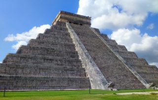
El Castillo – Dominating the center of Chichén is the giant Temple of Kukulkan often referred to as “El Castillo” (the castle). This huge step-pyramid served as a platform for the temple at the top where human sacrifices took place. It has staircases of 91 steps on each of the four sides (all these added together plus one more step to get to the temple makes 365, the number of days in a year.) Several thousand tourists show up during the spring equinox to see the light-and-shadow effect on the Temple of Kukulcan in which a snake supposedly can be seen to crawl down the side of the pyramid. Climbing the pyramid is no longer permitted.
Great Ball Court – Courts for playing the Mesoamerican ballgame have been found throughout the Maya region, and the largest is at Chichen Itza, measuring 545 feet long by 223 feet with 39 feet high walls, often with intricate carvings. The game used a solid rubber ball and may have ended with a human sacrifice. At the ends of the ball court are located two temples, also possessing intricate carvings or bas-reliefs.
Sacbe number one – This sacbe (road) is the largest at Chichen Itza (It is 890 feet long with an average width of 30 feet) and leads to the Cenote Sagrado.
Cenote Sagrado – The Yucatan Peninsula is a limestone plain, with no ground-level rivers or streams. The rivers and streams run underground, and come to the surface occasionally in the form of natural sinkholes, called cenotes, which expose the water table. The Cenote Sagrado is 200 feet in diameter with sheer cliffs that drop to the water table about 90 feet below. It was a place of pilgrimage for ancient Maya people who would conduct sacrificed humans there during times of drought. Archaeological investigations support this as thousands of objects have been removed from the bottom of the cenote, including material such as gold, jade, obsidian, shell, wood, cloth, as well as skeletons of children and men.
Temple of the Warriors – The Temple of the Warriors consists of a large stepped pyramid fronted and flanked by rows of carved columns depicting warriors. The archaeological expedition and restoration of this building was done by the Carnegie Institute of Washington in the 1920′s.
Group of a Thousand Columns – Along the south wall of the Temple of Warriors are a series of exposed columns which in former times would have supported an extensive roof system.
El Mercado – This square structure is so named for the shelf of stone that surrounds a large gallery and patio that was once thought to be used to display wares as in a marketplace.
El Caracol – Also called “The observatory,” this round building on a large square platform is nicknamed El Caracol (“the snail”) because of the stone spiral staircase inside. It is thought to be an observatory because its doors and windows are aligned to astronomical events, such as the path of Venus in the sky.
Numerous Other Buildings
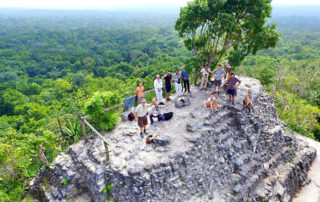
Caracol
Caracol Mayan Ruins
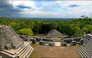
Caracol or El Caracol is the name given to the archaeological site located in the tourist-friendly Cayo District of Belize. It is located about 25 miles south of the town of San Ignacio in the foothills of the Maya Mountains within the Chiquibul Forest Reserve in western Belize near the border with Guatemala. This forest reserve is a largely undeveloped tract of primary and secondary tropical rain and pine forests. Caracol is huge. In fact, it is the largest Mayan site in Belize, and one of the largest in the Mayan world. The core area alone is 15 square miles and once supported a population of about 120,000 people.
The ruins are not well cleared nor excavated as are other ruins in the region. A visit to Caracol is often combined with a stop at the Río On Pools, or one or more of the other attractions in the Mountain Pine Ridge area, and its location in a forest reserve allows for great bird-watching and the chance to see other wildlife.
History
Ancient Caracol was occupied as early as 1200 BC. Its greatest period of construction was in the Maya Classic period, between 600 and 900 AD. The town grew into one of the largest ancient Maya cities, covering some 65 square miles with an estimated peak population of about 120,000 or more.
Many hieroglyphic texts have been found on stelae, alters, ball-court-markers, capstones and wall facades. The discovery of an elaborately carved ball-court-marker dating back to the end of the early Classic Period has been interpreted as Caracol claiming a military victory over Tikal, located more then 60 miles away in Guatemala.
Caracol was a densely populated city with a prowess in war. Not only against Tikal, but also against nearby Naranjo and Ucanal. Evidence suggests that the general population benefited from these wars which served as a catalyst for the city’s development. One monument records a military victory over the army of Tikal in 562 AD, where Caracol’s Lord Water is shown to have captured and sacrificed Tikal’s Double Bird.
Causeways (sacbeob) link all parts of the city of Caracol as well as outlying parts of the city to a distance of 25 miles. These causeways incorporated previously existing centers into Caracol, serving to integrate the economy. This included the local agriculture and markets which occurred within the city.
The Park
The site is open daily from 8am to 4pm; admission is BZ$15, less than US$10.
The complex covers 30-square miles of thick, high-canopy jungle, and includes five plazas, an astronomic observatory and over 35,000 buildings which have been identified. The tallest of them is a massive pyramid which is capped by three temples and rises over 140 feet above the jungle floor. A project of archaeological excavations and restorations started in 1985 and is ongoing; however, most of the site remains unexcavated. An on-site museum was opened in 1998, but only a small number of tourists visit daily.
Major Attractions
Caracol’s central core consists of three plaza groups surrounding a central acropolis and two ball courts, along with a number of smaller structures. The Visitor’s Center exhibits a number of photographs and diagrams of the site, along with artifacts, including a recovered ceremonial altar.
The main pyramid at Caracol is called Caana or “Sky Palace.” At 136 feet high it is the tallest Mayan building in Belize and the tallest man-made structure in the country. Caana contains four palaces and three temples. The palace rooms were originally coated with white stucco and decorated with red paint.
More than 100 tombs have also been found, as well as a rich array of hieroglyphic inscriptions.
Getting There
If you wish to drive to Caracol yourself, it is a good idea to rent a 4×4 vehicle, especially during the June-December wet season. Take the “Mountain Pine Ridge Road” southward from Santa Elena, or Georgeville; both on the Western Highway in the Cayo District. The route is well marked. There’s a small visitor center at the entrance, and a guide can sometimes be hired here; however taking a tour is recommended. There are numerous “Jungle Trails,” cave sites, gift shops, and other tourism-oriented attractions along the road through the Mountain Pine Ridge area.
Tours to Caracol are offered by all tour operators in the Cayo District, and your hotel or resort can arrange such a tour for about US$85 per person. Other day trips in the area include the ruins at Xunantunich, Pilar, and Cahal Pech all of which are located closer to the main town of San Ignacio.
Jaina Island
Introducing Jaina Island
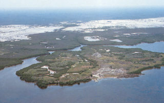
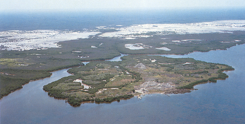
Jaina Island is a small limestone island in the Yucatan Peninsula about 50 miles north of the city of Campeche. Jaina was once an elite Maya burial site with an estimated 20,000 graves, of which about 1,000 have been excavated, and it is famous for the ceramic figurines which are found in the graves. The graves contain the human remains with one or more ceramic figurines on their chest or held in their hands as well as glassware, slate ware, pottery, hand woven cotton mats or other ceremonial objects. The island was first settled about 300 AD and was abandoned about 1200 AD. At present there is no park, no facilities, and it is closed to the public.
Attractions
Present-day ruins consist of two small plaza groups and a ballcourt. Visitors may also explore the island to enjoy the marine wildlife.
There is no museum on the island, but the famous figurines found there can be seen in museums around the world. The figurines are made of orange clay about 10 – 25 inches tall and are often painted. They are in a realistic style and reveal glimpses of the daily life of the Maya elite. They are “generally regarded as the finest figurine art produced throughout the ancient Americas”.
How To Get There
Jaina Island is closed to the public, but it is possible to get a special permit to go there. The best way would be to see a travel agent in Campeche who can do the paperwork and quickly get a permit. Once the permit is obtained, the travel agency can arrange for boat transportation to the island. It is also possible to access the island by land, but it is complicated.
Individuals can apply for a permit in person at the National Institute of Anthropology and History (INAH) in Campeche. The INAH or the Campeche state tourist office can offer assistance in getting transportation and guide service.
Dzibilchaltun Ruins, Merida
Dzibilchaltun Ruins, Merida
Dzibilchaltún (pronounced Ts’íibil Cháaltun) is a comparatively small Maya archaeological site in the Mexican state of Yucatán, approximately 10 miles north of the state capital Mérida. It is in the extreme north of the Maya Region, not far from the Gulf of Mexico. The site has been continuously occupied for about 3,000 years up until the arrival of the Spanish, and is known to be the longest functioning city of the Mayan world.
Archaeologists have studied nearly 35 sq km of the city, and the area that has been mapped includes over 8,000 structures, though most cannot be seen due to growth of trees and vegetation. It was once a wealthy port and center of Mayan coastal trade and had a peak population of about 20,000, although it declined with the rise of Chichen Itza. Restoration still continues here.
The Park
Hours: 8:00-5:00. Museum open 8:00-4:00. A small entrance fee to this national park includes the ruins, grounds, museum, cenote (swimming) and church. The Dzibilchaltun complex offers an information office, telephone, handicapped facilities, restrooms, parking, a small gift shop, and a restaurant. Private guides are available for a fee. Allow a half day to visit.
Major Attractions
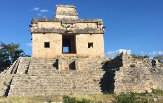
The most famous structure is the Temple Of The Seven Dolls (Templo de las Siete Muñecas), so named because of seven small dolls or figurines found inside. The temple was discovered by archaeologists in the 1950s under the ruins of a larger pyramid that was constructed over it. Building temples on top of temples was a common practice with the Maya. The dolls were found in the temple, but are now housed in the museum. An interesting feature of the temple occurs on the Spring and Fall equinoxes, the beginning of the planting and harvesting seasons. The doorways were constructed to capture the light of the rising sun on those days. As the sun rises it is visible directly through one door of the temple and out the other, filling it with sunlight. The site is opened at 5:30 a.m. on those two days so visitors can view the phenomenon.
There is an air conditioned museum on the premises that houses Mayan and Catholic artifacts from the site. Exhibits include carved stone tablets, stela, columns and lintels, old textile machinery, maps, Spanish armor, swords and other weapons, as well as information about the religious practices of the Mayans before and after their conversion to Catholicism.
When the Catholics arrived, they dismantled some of the buildings and used the stone to construct their own buildings including the 16th Century Franciscan church that now lies in ruins on the site. A sacbe (roadway) leading from the Temple of the Seven Dolls connects to the central plaza and an unusual arched structure call the Open chapel.
How to Get There
The ruins are located between Merida and Progresso and tours are available from those two cities. A taxi ride costs about US$10, and the #3 bus from Merida will take you to the road that leads to the site. If you are driving yourself take the Merida-Progreso highway north. After seven miles you will see the sign to turn right. Drive for about two more miles. You will see signs directing you to turn right after you pass the village.
El Mirador, the Lost City of the Maya
Introducing El Mirador
El Mirador is truly the lost Mayan city, a huge site (some say the largest Mayan city in existance) in the jungle of northern Guatemala. It is in the Mirador Basin, a vast area of virgin rain forest which also contains dozens of Mayan ruins including several large cities, the largest of which is the one known as El Mirador (which means “The Lookout”). The site is known as the cradle of Mayan civilization and is home to several huge structures and many square miles of unrestored mounds and pyramids in the jungle, covered in vegetation. It has been called the oldest and most extensive Mayan site in the world, covering 38 square miles, larger than the city of Los Angeles. No hotels, restaurants or tourist facilities. There are archeologists working there, however.
History
El Mirador flourished as a trading center from around 200 BC to 150 AD during what is known as the Maya Pre-Classic Period. Thus, it is a very early Mayan settlement. With a population as high as 100,000, it was one of the first large cities in the Americas, but then lost its population and was perhaps even abandoned. It later regained some population, but finally was abandoned for good in about 900 AD in the great Mayan collapse. There is no permanent population today.
The ruins of El Mirador were discovered in 1926. Since then they have been the object of periodic investigations, mappings, studies and excavations, but they remain largely unexcavated and covered in vegetation.
The Park
The Mirador Basin in northeastern Guatemala is home to the largest tract of virgin rainforest in Central America. Within this region lies the remote site of El Mirador, the largest Mayan city that ever existed. The civic center of the site covers some 10 square miles with several thousand structures, including monumental architecture covered in vegetation. Among the ruins at El Mirador are the Danta and Tigre pyramids, the former said to be the largest pyramid in the world in terms of volume.
Largely unexcavated, the complex of El Mirador is not yet developed for tourism. However, the Guatemalan government recently announced plans to create a tourist park in the area, making access to this remote site more accessible. But such a project will take years to develop.
Major Attractions
The city’s main group of buildings covers two square kilometers and many were built on a grand scale, such as the “El Tigre” complex and the “La Danta” complex. El Tigre rises to about 180 feet tall, and its base covers 14 acres. The La Danta complex has a base that would cover 35 football fields. On top of this base is a series of plazas, temples, pyramids and other structures reaching to a total height of 230 feet, making it one of the tallest of all Mayan structures.
The view from the top of El Tigre is mostly of jungle and other ruins, such as Calakmul and Nakbé in the distance. However, any mound or group of mounds that you can see as far to the horizon are former cities.
An additional feature of El Mirador is the quantity and size of causeways, connecting important points within the city and also extending out to other major cities within the Mirador Basin. The causeways (known as sacbeob) are raised stone causeways rising 2 to 6 meters above the level of the surrounding landscape and measuring from 20 to 50 meters wide.
How to Get There
Getting to El Mirador is difficult. There are no roads or rivers leading to the site, so you have two choices: hike (a five-day round trip journey usually made with the help of horses or mules), or hire a helicopter to fly you in. Tours of El Mirador are generally arranged with guides and agents based in the northern Guatemalan village of Flores which can be reached by air from Guatemala City. A tour is recommended. Many agencies in Flores and Santa Elena can arrange a tour, including transportation to Carmelita and back.
The village of Carmelita is the nearest point to the site that you can go by car. There you will find guides and rental of needed equipment. A community visitor center is under construction with lodging, tourism center, internet and computer facilities, guiding center and other services.
Palenque
Introducing Palenque
Palenque (Pronounced pa-LEN-kay) is a town in the southern state of Chiapas located about 90 miles SE of the city of Villahermosa and about 150 miles NE of San Cristobal de las Cases. It is also the site of a huge set of ruins within a national park visited by thousands annually. Many believe it is the best archeological site in the country because of the mystical setting in the jungle and because of the incredible architecture of the ruins. The ruins of Palenque have an awe-inspiring setting, overlooking the jungle from part way up some thickly forested mountains.
Palenque is a medium-sized site, but it contains some of the finest architecture, sculpture, roof comb and bas-relief carvings. After its decline it was absorbed into the jungle, but has been partly excavated and restored and is now a famous archaeological site attracting thousands of visitors. Palenque contained tombs of ancient leaders and rulers, and still today, excavations are ongoing to uncover more. Some of the site is still roped off to visitors as work to uncover the hidden treasures, reclaimed by nature over centuries of disuse, continues. A relatively small number of the estimated 500+ buildings have been excavated.
The surrounding forest is home to a huge variety of wildlife including toucans and monkeys.
Five miles from the ruins is the town of Palenque. There you can find lodging and food, as well as make travel arrangements. Transportation between the town and ruins is cheap and convenient.
History
Palenque began about 100 BC, but did not become a major population and important religious center until about 600 AD. At this time their greatest ruler, Pacal, came into power and ruled for 68 years. During his rule, he emphasized the construction of grand buildings.
During the 8th century, the city decreased in importance and building on a grand scale ended. The city was abandoned but a small agricultural population continued to live there for a time. The city was slowly engulfed by the forest. The district was very sparsely populated and unrecognizable as a city when the Spanish first arrived in the 1520s. Two hundred years later the ruins started to become known to the Europeans, and they were gradually explored. Excavation and restoration began in the 1900′s and has accelerated in the last 20 years, but archaeologists estimate that only 5% of the total city has been uncovered
The most impressive excavation of the 1900′s was made by the Mexican archaeologist Alberto Ruz. In 1949 he determined that the floor of the Temple of the Inscriptions must conceal something. Lifting the huge polished floor stones of the rear chamber he found a steep staircase, tightly packed with tons of stone fill. Three years later he opened the great tomb of Pacal, for the first time in more than a thousand years with its beautiful sculptures and jades.
By 1968, good roads had reached the site, and so began the influx of tourists.
The Park
The Parque Nacional Palenque, which contains the ruins, is open every day from 8 to 5 with a modest admission charge of less than US$10. A museum and visitor center, small but worth a visit, sits not far from the entrance to the ruins. It contains artistic exhibits, including jade from excavated tombs. Explanatory text in Spanish and English explains the history of ancient Palenque. At the main entrance, about 1/2 mile past the museum, you will find a large parking lot, a refreshment stand, a ticket booth, and several shops, and the inevitable vendors. The best way to explore the site is to enter through the main (north) entrance, visit the main temples and structures and then wander around the fringe temples.
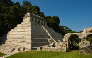
Templo do las Inscripciones
The main, and most attractive ruin is the Templo de las Inscripciones (Temple of Inscriptions), named for the great stone hieroglyphic panels found inside, most of which are now in the National Anthropological Museum in Mexico City. This Pyramid measures about 90 feet high and serves as a platform for the summit temple, another 35 feet high. The largest stones (located on top of the Pyramid) weigh 12 to 15 tons. It is a funerary monument and holds the crypt of King Pacal deep inside.
El Palacio
El Palacio (The Palace) is a a complex of several connected and adjacent buildings and courtyards built up over several generations on a wide artificial terrace. The Palace houses many fine sculptures and bas-relief carvings in addition to the distinctive four-story tower.
Next to the Temple of the Inscriptions is Temple 13, which has recently become more important because of the discovery of another rich burial site.
The Cross Group
A path between the Palace and the Temple of the Inscriptions leads to a group of temples including: the Temple of the Sun, the Temple of the Foliated Cross, the Temple of the Cross, and Temple 14. This group of temples is now cleared and in various stages of reconstruction. Each sits on top of its own step pyramids and contains carved reliefs in the inner chambers.
The North Group
To the left of the Palace is the North Group, also undergoing restoration. Included in this area are the Ball Court (where a game a little like basketball was played with a solid rubber ball ofter ending in the sacrifice of some of the players) the Temple of the Count (so named because a European count lived in it for a time), and at least three tombs.
Others
There is an aqueduct constructed of stone to make the Otulum River flow underneath the floor of Palenque’s main plaza. A stone bridge downstream from the aqueduct. Numerous other temples, tombs, and palaces. The rain forest and its city of ruins covered in vegetation.
How to get there
Palenque is located in the state of Chiapas, 90 miles SE of Villahermosa and 150 miles NE of San Cristóbal de las Casas
By Air: The closest airport is Villahermosa.
By Car: The drive from San Cristóbal to Palenque takes 5 hours and passes through jungle and mountain scenery. Watch out for potholes and other hindrances. Hwy. 186 from Villahermosa should take about 2 hours. You may encounter military roadblocks. Do not drive at night and exercise a lot of caution.
By Bus: Bus service to Palenque is available from San Cristóbal (5 hr.), Tuxtla (6 1/2 hr.), Campeche (5 hr.), Villahermosa (2 hr.), and Mérida (9 hr.).
Visitor Information — The downtown tourism office is a block from the main square at the corner of Avenida Juárez and Abasolo.
Getting to the Ruins — The cheapest way to get back and forth from the ruins is on the white vans (colectivos) that run down the main street every 10 minutes from 6am to 6pm. The buses can be flagged down at any point, and the cost is 10 pesos per person. A taxi is always a good option.
Over Night – Many travelers believe that Palenque requires a whole day to appreciate fully. One plan is to stay at a hotel in Palenque (or in one of the hotels next to the park), get an early start, and get to the park before the tour buses and the extreme heat arrive.
Protect Yourself – Palenque is in the middle of the jungle. It is hot and humid, so dress appropriately with cotton clothes and no denim. Wear sturdy, comfortable shoes. Protect yourself with sun screen, bug spray, a hat, sun glasses and lots of water. Drink the water before you become thirsty.